


Assessment Mapping With Google Earth
Download Google Earth Pro for PC or Mac
http://www.google.com/earth/download/gep/agree.html Note: Google Earth Pro requires a license key. If you do not have a key, use your email address and the key GEPFREE to sign in
After download
- Open Google earth and use your email address and the key GEPFREE to sign in.
- Sign in with Google Email.
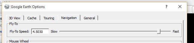
- Click-Tools-Options-Navagation-Change fly to speed
Import
Download and sort .csv in Excel (city/state/zip*)
Click File-Import
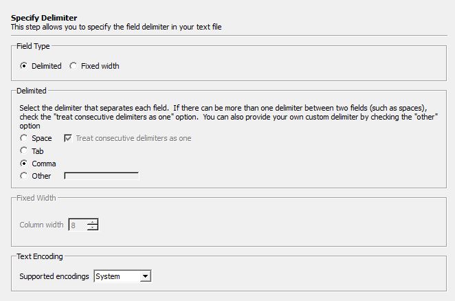
Keep setting above and click next
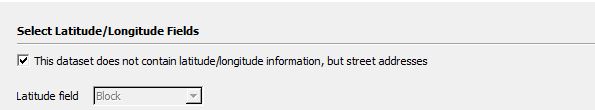
Check box if no latitude/longitude is available.
Click Finish
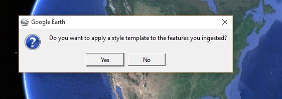
Click NO
National Flood Hazard
National Wetlands Data
Wetlands-Data.kml (last modified on May 1, 2014)
Google Earth Pro data import tools
Import GIS data into Google Earth
Where to find the Data?
New Jersey County Tax Boards Association
The official website of the New Jersey County Tax Boards Association.

Cama Download
Microsystems Spreadsheet
- 32 - Reports & Misc Printing
- 43-Style/Neighborhood Anal
- 3 - Download to Excel
- Sort Option: N=Current
- 1: Blocks
- Hit enter twice (Starting Block: Starting Lot : )
- Do you want only ONE Record? (y or n) n
- Hit enter twice (Stop After Block: Stop After Lot : )
- Hit Enter Start At B: L: 1 Q:
- Stop After B: 99999 L: 99999 Q:
- Hit enter twice
- Do you want Tax List or Current Calculation Values? (t or c) t
- Click window-Open C:Tmp
- Open styneigh-Save As Excel workbook
- Remove undesired fields.
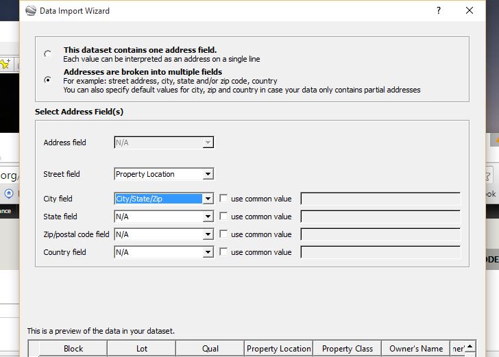
- Add address for geocoding. (see below)
To add address for geocoding:
- Insert two columns to the right of property location.
- Add City State Zip to one column. (Note: Start on second line, use commons to separate) copy and paste to all fields.
- Use command =CONCATENATE(E2,",",F2) to combine first and second row. Drag down to complete all.
- Copy completed column and paste special “values “into property location column. Rename “Full Address”.
- Create desired number of copies and rename (Example: Over 100, 95-99, 94-65)
- Sort Z-A filter. (Note: must click entire column and be prompted by sort warning to “expand the selection” or all data will be lost).
- Chose sample size and delete undesired sales. Re-sort and remove NU’s.
- Save as single sheet (drag tab into open area)
Creating Fusion Table
- Drive.google.com.
- Click-Create, Click-Fusion Table.
- Click-Choose File, Select spreadsheet.
- Next to load, Next to import, Finish to create.
- Click on the drop down under “Full Address” , Click-change type to “location” , Click-save changes.
- Click-File, Click-Geocode, Click-Begin geocoding
- Click red +, click- add map (if needed)
- While on map tab- Click File, Download, select KML or KML Network Link for "live data", Download.
Using Buckets to Sorts Sales by Price and Adding Legend
- In map tab select, Change feature style, click buckets tab.
- Divide into buckets needed (10 max).
- In Column, select sales price, click use this range or change to whole numbers (recommend).
- Select Legend, check show marker legends.
- Click Save
- Take screenshot of legend and see below for Adding legends, logos and banners to Google Earth with Screen Overlays.
Note: to change info that appears in window when you click on a balloon use "Change info window" and select desired columns, click save.
Links to KMZ
Click on link below to open map, click file, download.
Link for in earth quick links
Adding legends, logos and banners to Google Earth with Screen Overlays
- Click Here for how to create the code
- Or Click here for the free KML Screen Overlay Maker Utility (select the "full packaged install")
Converting .SHP and other GIS file layer to KMZ
-
Click Here to download Ogr2gui, a simple software solution.
Video Tutorials Overlaying Images Over Google Maps & Satellite Images Using Google Earth Tutorial on how to create a Google Fusion Table map visualization Excel and mapping polygons Excel and mapping with Fusion Tables Learn Google Earth: Importing KML, KMZ and GPS Data